NCERT Solutions for Class 6 – Complete Chapter-wise Study Material
Chapter 4. Maps is one of the most important chapters in the Class 6 Geography English NCERT Solutions curriculum. This chapter plays a significant role in helping students build a strong conceptual foundation while preparing for school examinations, class tests, unit tests, half-yearly examinations, annual examinations, and CBSE board assessments. The chapter has been carefully designed according to the latest NCERT syllabus, making it an essential part of every student's study plan.
The Chapter 4. Maps - Class 6 Geography English NCERT Solutions available on ATP Education explain every question in a simple, accurate, and step-by-step manner. Each answer is prepared according to the latest CBSE guidelines so that students can understand the concepts clearly without confusion. Whether you are completing your homework, revising before examinations, or strengthening your understanding of the subject, these solutions provide reliable academic support throughout your learning journey.
One of the biggest advantages of studying Chapter 4. Maps is that it helps students understand important concepts, definitions, examples, and textbook exercises in an organized way. Instead of memorizing answers, students learn how to develop logical thinking, improve analytical skills, and write well-structured answers in examinations. This chapter also helps improve problem-solving ability and encourages conceptual learning, which is essential for scoring higher marks in school and competitive examinations.
Our Class 6 Geography NCERT Solutions cover all textbook questions, important exercise questions, and chapter-wise explanations in English Medium. Every solution is written in easy-to-understand language, allowing students to revise the chapter quickly before examinations. Regular practice of these solutions improves confidence, strengthens subject knowledge, and reduces examination stress.
Students preparing for school assessments should carefully study Chapter 4. Maps because questions from this chapter are frequently asked in objective questions, short answer questions, long answer questions, competency-based questions, and case-study questions. Understanding the concepts explained in this chapter also helps students connect related topics from other chapters, making overall learning more effective and meaningful.
At ATP Education, we continuously update our Class 6 Geography English NCERT Solutions according to the latest NCERT textbooks and CBSE curriculum. Students can confidently use these chapter-wise solutions for daily study, homework assistance, quick revision, examination preparation, and self-learning. By studying Chapter 4. Maps thoroughly and practising every question regularly, students can strengthen their concepts, improve writing skills, and achieve better academic performance in both school and board examinations.
Chapter 4. Maps - Class 6 Geography English NCERT Solutions
Chapter 4. Maps
chapter - Review:
- Physical maps are also known as relief maps. They show the natural features of the earth like mountains, plains, plateaus, oceans, river, etc.
- Political maps show cities, towns and villages of different countries and states with demarcated boundaries.
- Thematic maps focus on a piece of particular information such as roads, rainfall distribution, forest distribution, industries, etc. Accordingly, titles are given to such on the basis of the information they provide.
- Maps are a two - dimensional representation of the earth. It is a reduced from of the entrie world of it on a small sheet of paper. Hence, it is extremely important to pay attention to represent the distance between two places on map. This will help us in finding the actual distance between those two places.
- Distance is an important parameter in map study. Distance determine scales which is very important for any map.
- The scale is the ratio between the actual distance on the ground and the distance on the ground and the distance portrayed on the map.
- The scale helps you to calculate the actual distance between two points on a map.
- When large areas like countries or even continents are to be shown on a map we small scales and these maps are called small scale maps.
- When a small region like a village or a town is to be shown on a map in great detail we large scales and these maps are called large - scale maps.
- The four major directions North, South, East and West are called cardinal points.
- There are four intermediate directions also. They are north - east, south - east, north - west and south - west.
- A compass is used to find the direction of a place. A compass can be defined as an instrument that finds out the main directions or intermediate directions of a place concerning another. It has a magnetic needle that ponts towards the
north - south direction when resting.
- Compasses have been used by travellers and sailors since ancient times. It is a small circular box with magnetic neeble fitted inside it.
- Symblos are used for the convenience of map study.
- Features like buildings, bridges, trees, railway lines, roads, etc, are to be shown on maps. For this purpose, symbols are used.
Chapter 4. Maps
Exercise - Question:
Q1. Answer the following questions briefly.
(a) What are the three components of a map ?
Ans. The three components of a map are distance, direction and aymbols.
(b) What are the four cardinal directions ?
Ans. The four cardinal directions are North, South East and West.
(c) What do you mean by the term 'scale of the map' ?
Ans. Scale of the map is the ratio between the actual distance on the ground and the distance on the map.
(d) How are maps more helpful than a globe ?
Ans. A globe can be useful when we want to study the earth as a whole. But if we want to study only a part of the earth, e.g. , a continent or a country, it is of little help.
Map is the representation or a drawing of the earth's surface or a part of it drawn on a flat surface. It gives more information than a globe.
(e) Distinguish between a map and plan.
Ans. A map is a representation or a drawing of the earth's surface or a part of it drawn on a flat surface, according to a scale.
A plan is a drawing of a small area on a large scale. There are certain things we sometimes want to know, e.g. length and breadth of a room, which cannot be shown in a map. So we refer to drawings drawn to scale called a plan.
(f) Which map provides detailed information ?
Ans. Large scale maps provide detailed information.
(g) How do symbols help in reading maps ?
Ans. It is not possible to show and draw the actual shape and size of different features, e.g. , railways buildings. So they are shown with various symbols. symbols give much information in a limited space. With the use of symbols, maps can be drawn easily and are simple to read.
Q2. Tick the correct answers.
(a) Maps showing distribution of forests are
(i) Physical map
(ii) Thematic map
(iii) Political map
(b) The blue color is used for showing
(i) Water bodies
(ii) Mountains
(iii) Plains
(c) A Compass is used
(i) To shows symbols
(ii) To find the main direction
(iii) To measure distance
(d) A scale is necessary
(i) For a map
(ii) For a sketch
(iii) For symbols
Ans. (a) (ii), (b) (i), (c) (ii), (d) (i)
Chapter 4. Maps
Additional Question:
Que: When do you use a globe?
Ans: We use a globe when we want to study the earth as a whole.
Que: What is an antlas?
Ans: An atlas is a collection of maps.
Que: What do physical maps show?
Ans: Political maps show natural features of the earth such as mountains, plateans, plains, rivers, oceans, etc.
Que: What do political maps show?
Ans: Political maps show cities, towns and villages and different countries and state of world with their boundaries.
Que: What do you mean by a thematic map?
Ans: A map which gives focus on specific information is konwn as thematic map. For example, road maps, maps showing distribution of industries, etc.
Que: Differentiate between a small scale maps and a large scale map.
Ans:
(i) A small scale map is used to show large areas like continents or countries on a paper while a large scale map is used to show area such as village or town on a paper.
(ii) A large scale map is more informative than a small scale map.
Que: What is called the northline?
Ans: Maps usually contain an arrow marked with the letter 'N' at the upper right hand comer. This arrow shows the north direction and is called the north line.
Que: What is a compass?
Ans: A compass is an instrument used to find out main directions.
Que: What are conventional symbols?
Ans: Some symbols have a fixed meaning and are understood uniformally through out the world. Such symbols are known as conventional symbols.
Que: What colours are used for the following:
(i) mountains
(ii) plain
(iii) plateaus
(iv) water bodies
Ans:
(i) Mountains - Brown colour
(ii) plains - Green
(iii) plateaus - yellow
(iv) water bodies - Blue
Que: What is a sketch map?
Ans: A sketch map is a rough drawing of an area. It is draw without scale.
Que: What is plan?
Ans: A paln is a drawing of a small area on a large scale.
Que: Differentiate between scale map and a large scale map.
Ans:
(i) A small scale map is used to show large areas like continents or countries on a paper while a large scale map is used to show a small area such as village or town on a paper.
(ii) A large scale map is more informative than a small scale map.
Que: What are cardinal points and intermediate directions?
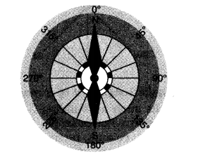
Ans: The four major directions - North, South, East and West are called cardinal points. Beside these major directions we have intermediate directions - North - East (NE), South - East (SE), south - West (SW) and North - West (NW). The intermediate directions are very helpful in locating any placce more accurately.
Que: Write a note on 'compass'.
Ans: The direction of a place is traced out with the help of a compass. It is an instrument Used to find our main directions. It magnetic needle always points towards north - south direction.
Que: Define and discuss 'distance' as a component of a map.
Ans: Maps are drawing. They reduce the whole world or a part of it to fit on a sheet of paper. In other words we ca say that maps are drawn to reduced scales. but it needs great care while doing this reduction work in order to keep the distance between the real places. It can be possible when a small distance on paper represents a large distance on the ground. For this purpose a scale is used.
Scale is the between the actual distance on the ground and the distance shown on the map. We can understand this with the help of an example. Suppose, the distance between your coaching centre and your school is 8km. If you show this 8km distance by 2cm on a map. It means, 1cm on the map will show 4km on the ground. Thus, the scale of your drawing will be 1cm = 4km scale is very important in any map.
If scale is known, calculation of distance between anyb two places on a map will be easy. A small scale is used to show large areas on a paper like continents or countries. For example, 10cm on the map shows 1000km of the ground. A large scale is used to show a small area like a village or town on paper. For example, 10cm on the map shows 1000 metres only on the ground.
Que: GIve an account of 'direction' as a major component of a map?
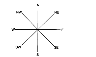
Ans: Direction is an important component of a map. Most maps contain an arrow marked with the letter 'N' at the upper right hand comer. This arrow show the north direction. It is called the north line. After knowing the north direction, other directions, east, west and south can be easily found out.
There are four major directions - North, South, East and West. They are called cardinal points. Besides these, there are four intermediate directions. They are north - east (NE), south - east (SE), south - west (SW) and north - west (NW). Location of any place with more accuracy can be possible with the help of these intermediate directions.
:
Que: Discuss symbols as a major component of a map.
Ans: Drawing different features such as building, roads, etc. in their actual shape and size on a map is perhaps not possible, it is therefore, they are shown by using certain letters, shapes, colours, pictures and lines. These are symblos that give a lot of information is a limited space.
With the use of these symbols, maps can be drawn easily and are simple to read. These symbols help us greatly in a situation when don't know the language of an area and therefore cannot ask someone for directions. We can collect information from maps with thw help of these symblos.
Maps have a universal language known and understood by all. There is an international agreement regrading the use of these symbols, which are known as conventional symbols.
NCERT Book Solutions
Chapter-wise NCERT Solutions for Class 6 to 12 prepared according to the latest CBSE syllabus.
HINDI MEDIUM
NCERT Solutions Class 6
Chapter Chapter 2. Globe Latitudes and Longitudes Solutions
Chapter 2. Globe Latitudes and Longitudes Open Chapters
Explore Now →
NCERT Solutions Class 6
Chapter Chapter 3. Motions of the Earth Solutions
Chapter 3. Motions of the Earth Open Chapters
Explore Now →
NCERT Solutions Class 6
Chapter Chapter 4. Maps Solutions
Chapter 4. Maps Open Chapters
Explore Now →
NCERT Solutions Class 6
Chapter Chapter 5. Major Domains of the Earth Solutions
Chapter 5. Major Domains of the Earth Open Chapters
Explore Now →
NCERT Solutions Class 6
Chapter Chapter 6. Major Landforms of the Earth Solutions
Chapter 6. Major Landforms of the Earth Open Chapters
Explore Now →
NCERT Solutions Class 6
Chapter Chapter 7. Our Country-India Solutions
Chapter 7. Our Country-India Open Chapters
Explore Now →
NCERT Solutions Class 6
Chapter Chapter 1. The Earth in the Solar System Solutions
Chapter 1. The Earth in the Solar System Open Chapters
Explore Now →
NCERT Solutions Class 6
Chapter Chapter 8. India Climate, Vegetation and Wildlife Solutions
Chapter 8. India Climate, Vegetation and Wildlife Open Chapters
Explore Now →
NCERT Solutions Class 6
Chapter 1. The earth in the solar system Solutions
1. The earth in the solar system Open Chapters
Explore Now →
NCERT Book Solutions
Chapter-wise NCERT Solutions for Class 6 to 12 prepared according to the latest CBSE syllabus.
ENGLISH MEDIUM
NCERT Solutions Class 6 Mathematics
Class 6 Mathematics Book Solutions
Mathematics Open Book
Explore Now →
Benefits of Studying NCERT Solutions
Studying from NCERT Solutions helps students build strong conceptual understanding and improve problem-solving skills. These solutions are especially useful for revision because every answer is written according to the marking scheme followed by CBSE.
- Improve conceptual understanding.
- Learn correct answer-writing techniques.
- Prepare effectively for school examinations.
- Complete syllabus revision in less time.
- Practice important textbook questions.
- Build confidence before examinations.
Prepared According to the Latest CBSE Syllabus
All NCERT Book Solutions for Class 6 available on ATP Education are updated according to the latest CBSE curriculum. Whenever NCERT introduces changes in textbooks or syllabus, our study materials are revised accordingly so that students always receive accurate and updated content.
Helpful for Competitive Examinations
NCERT textbooks form the foundation of many competitive examinations. Students preparing for Olympiads, NTSE, CUET, UPSC Foundation, SSC and several entrance examinations can strengthen their basics through these chapter-wise solutions. Understanding NCERT concepts also improves analytical thinking and logical reasoning.
Simple and Student-Friendly Explanations
Our experts prepare every answer in a simple, clear and student-friendly format. Difficult concepts are explained step by step with proper reasoning so that students of every learning level can understand them easily. This approach helps students remember concepts for a longer period and perform confidently during examinations.
Start Learning with ATP Education
Explore the complete collection of NCERT Solutions for Class 6 and begin your preparation with confidence. Every chapter is available online for free and can be accessed anytime. Whether you want to complete homework, revise important chapters or prepare for examinations, ATP Education provides reliable and high-quality study resources to help you achieve academic success.